1. INTRODUCTION Drought is a normal and recurrent feature of the climate. It occurs in virtually all climatic zones, and its characteristics vary significantly among regions. Drought differs from aridity in that drought is temporary; aridity is a permanent characteristic of regions with low rainfall. Drought produces a complex web of impacts which spans many sectors of the economy, reaching well beyond the area experiencing direct drought. This complexity exists because water is essential to society's ability to produce goods and services. The intensity, duration, and frequency of droughts have a major influence on society.
Dracup et al. (1980) have studied drought characteristics in terms of severity, duration, and magnitude, wherein magnitude is defined as the ratio of severity over duration. According to Ponce et al. (2000), intensity is akin to severity; therefore, intensity is equal to magnitude times duration. The relations between drought intensity, duration and frequency can be analyzed using the conceptual model developed by Ponce et al. (2000), shown in Table 1. The conceptual approach is applicable to subtropical and midlatitudinal regions, and is limited to meterorloical droughts lasting at least one year.
In the Ponce et al. model, the climate types, which encompass the climatic spectrum from superarid to superhumid, are defined in terms of the ratio of mean annual precipitation Pma to (mean) annual global terrestrial precipitation Pagt. The ratio Pma / Pagt = 1 represents the middle of the climatic spectrum.
The conceptual model is also defined in terms of the ratio of annual potential evapotranspiration Eap to mean annual precipitation Pma. The ratio Eap / Pma = 2 describes the middle of the climatic spectrum. To complement the description, the length of rainy season Lrs is also indicated. For any year for which P is the annual precipitation, drought intensity is defined as the ratio of the deficit (Pma - P) to the mean (Pma). For any one year, an intensity of [(Pma - P) / Pma] = 0.25 is classified as moderate; 0.5 is severe, and 0.75 is extreme. For drought events lasting more than one year, intensity is the summation of the individual annual intensities. Therefore, the longer the drought duration, the greater the intensity. Extreme drought intensities are generally associated with droughts of long duration. The dry periods (droughts) are generally followed by corresponding wet periods. Therefore, the drought recurrence interval (i.e., the reciprocal of the frequency) is always greater than the drought duration. Drought recurrence intervals increase from 2 yr on the dry side of the climatic spectrum (superarid) to 100 yr on the wet side (superhumid). 2. THE OJOS NEGROS REGION
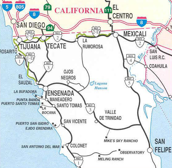
The Ojos Negros valley and environs are located in Baja California, Mexico, about 80 km south of the U.S.-Mexico border, as shown in figure 1. Recorded human settlement originated with the discovery of gold mining in 1870. Later, the local economic activities shifted first to animal husbandry and then to agriculture. At present, agriculture is the most important activity in the valley.
The Ojos Negros valley is drained by Ojos Negros Creek, a tributary of El Barbon Wash. 3. CLIMATOLOGY The Ojos Negros region has an arid climate, with rainy season in the winter (November to April) and extreme temperature variability. The climate is charaterized as cold and humid in the winter, and hot and dry in the summer. The ecosystem associated with this type of climate and geographical location is commonly referred to as "Mediterranean," which prevails throughout coastal northern Baja California and coastal Southern California.
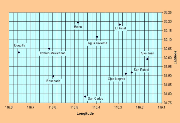
The study area is that encompassed within ten climatological stations located between 31°47'03'' and 32°11'43'' North latitude and 116°09'54'' and 116°45'16'' West longitude (figure 2). The length of the record varied from 21 yr in Valle de San Rafael to 72 yr in Ensenada. The following climatic variables were measured daily: (1) precipitation, (2) actual temperature, measured at 7 am,
The distribution of monthly temperature throughout the year is unimodal, i.e., there is typically only one maximum and one minimum. Mean annual temperature varies from 12.5°C to 18.6°C. The mean temperature of the hottest month (July/August) varies from 19.8°C to 26.3°C. Conversely, the mean temperature of the coldest month (January) varies from 6.6°C to 13.6°C. Mean annual precipitation varies from 235 mm to 517 mm, with about 20 percent occurring in the wettest month (January), and 0.25 percent in the driest month (June). The precipitation is markedly seasonal, with most of the precipitation occurring in the November-April period. The number of days per year when rainfall exceeds 0.1 mm (an indicator of the number of storms per year) ranges from 20 to 40. 4. DROUGHT CHARACTERIZATION Drought characterization in the Ojos Negros region has been performed using the conceptual model developed by Ponce et al. (2000). Drought intensity, duration and frequency for the ten climatological stations selected for this study are shown in Table 2.
Drought intensity (per event) vaires from 0.61 to 1.23, with an average of 0.83. Drought duration ranges from 2 to 3 yr, with an average of 2.46 yr. Drought frequency ranges from 3.50 to 4.83 yr, with an average of The longest mean drought duration occurred at Boquilla de Santa Rosa, El Pinal and San Juan de Dios Norte (3 yr), and the shortest at Ojos Negros (2 yr), with an average of 2.46 yr.
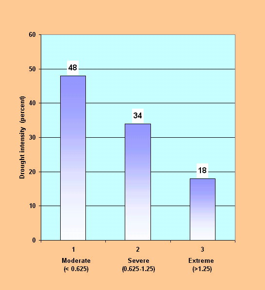
For all stations, event intensities were ordered and divided into the following categories, (based on an average duration of 2.5 yr): (1) moderate (less than 0.625), (2) severe (0.625-1.25), and
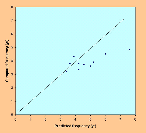
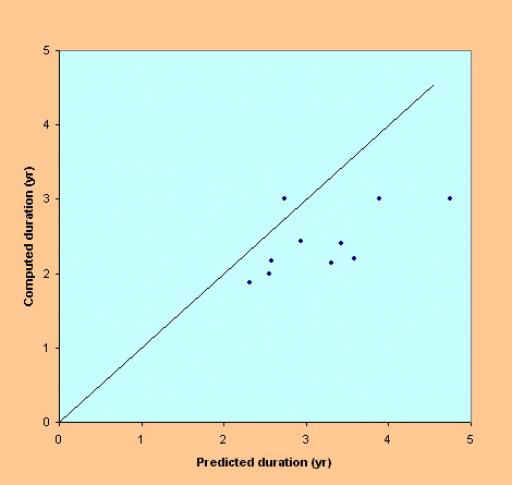
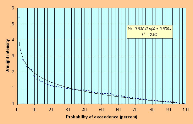
Drought duration and frequency were compared using predicted and measured values, as shown in figure 4. It is seen that model predictions agree reasonably well with measured data. Figure 5 shows drought intensity vs probability of exceedence. The lognormal curve fitting shows a very high coefficient of determination (0.95).
5. SUMMARY AND CONCLUSIONS Drought characterization has been performed for the Ojos Negros region and its vicinity, in Baja California, Mexico, close to the U.S.-Mexico border. A conceptual model developed by Ponce et al. (2000) was used in the characterization. Climatological data for ten (10) stations, with record length varying from 21 to 72 yr, were analyzed for drought intensity, duration, and frequency.
Intensity (per event) varied from 0.61 to 1.53, with an average of 0.83. Duration ranged from 2 to 3 yr, with an average of 2.46 yr. Frequency ranged from 3.33 to 4.83 yr, with an average of 3.96 yr. Based on the characterization, the study region is classified as arid according to drought duration ACKNOWLEDGMENTS The climatological data on which this study was based was obtained from the Comision Nacional del Agua, Gerencia Regional de Baja California, Mexicali, Baja California, Mexico. REFERENCES
DRACUP, J. A., K. S. Lee, and E. G. Paulson, Jr. 1980. On the statistical characteristics of drought events.Weter Resources Research, 16(2), 289-296.
PONCE, V. M., R. P. Pandey, and S. Kumar. 1999. Groundwater recharge by channel infiltration in El Barbon basin, Baja California, Mexico. Journal of Hydrology, 214,1-7.
PONCE, V. M., R. P. Pandey, and S. Ercan. 2000. Characterization of drought across the climatic spectrum. Journal of Hydrologic Engineering, ASCE, 5(2), 222-224.
SHARMAT, C. 1997. "A drought frequency formula" Hydrological Sciences Journal 42(6), 803-814.
| ||||||||||||||||||||||||||||||||||||||||||||||||||||||||||||||||||||||||||||||||||||||||||||||||||||||||||||||||||||||||||||||||||||||||||||||||||||||||||||||||||||||||||||||||||||||||||||||||||||||||||||||||||||||||||||||||||||||||||||||||||||||||||||||||||||||||||||||||||||||||||||||||||
| 211230 |
| Documents in Portable Document Format (PDF) require Adobe Acrobat Reader 5.0 or higher to view; download Adobe Acrobat Reader. |
