|
|
| 1. DEFINITION OF DROUGHT |
|
Drought is a weather-related natural disaster. It affects vast regions for months or years, and it is often aggravated by human action. It has an impact on food production and it reduces life expectancy and the economic performance of large regions or entire countries.
Drought is a recurrent feature of the climate. It occurs in virtually
all climatic zones, and its characteristics vary significantly among regions.
Drought differs from aridity in that drought is temporary; aridity is a permanent
characteristic of regions with low rainfall.
Drought is an insidious hazard of nature.
It is related to a deficiency of precipitation over an
extended period of time, usually for a season or more.
This deficiency results in a water shortage for some activity, group, or environmental sector.
Drought is also related to the timing of precipitation.
Other climatic factors such as high temperature,
high wind, and low relative humidity are often associated with drought.
Drought is more than a physical phenomenon or natural event.
Its impact results from the relation between a
natural event and demands on the water supply, and it is often exacerbated by human activities.
The experience from droughts has underscored the vulnerability of all
societies to this natural hazard.
Drought definitions fall in two categories: (1) conceptual, and (2) operational.
Conceptual definitions help understand the meaning of drought and its effects.
For example, drought is a protracted period of deficient precipitation which causes extensive
damage to crops, resulting in loss of yield.
Operational definitions help identify the drought's beginning, end, and degree of severity.
To determine the beginning of drought,
operational definitions specify the degree of departure from the precipitation average
over some time period. This is usually accomplished
by comparing the current situation with the historical average. The threshold
identified as the beginning of a drought (e.g., 75% of average precipitation over a
specified time period) is usually established somewhat
arbitrarily. An operational definition for agriculture may compare daily precipitation to evapotranspiration to determine the rate of soil-moisture depletion, and express these relationships in terms of drought effects on plant behavior. Operational definitions are used to analyze drought frequency, severity, and duration for a given historical period. Such definitions, however, require weather data on hourly, daily, monthly, or other time scales and, possibly, impact data (e.g., crop yield). A climatology of drought for a given region provides a greater understanding of its characteristics and the probability of recurrence at various levels of severity. Information of this type is beneficial in the formulation of mitigation strategies. The various types of droughts are listed below.
Meteorological drought is defined on the basis of the degree of dryness, in comparison to a normal or average amount, and the duration of the dry period. Definitions of meteorological drought must be region-specific, since the atmospheric conditions that result in deficiencies of precipitation are highly region-specific. The variety of meteorological definitions in different countries illustrates why it is not possible to apply a definition of drought developed in one part of the world to another. For instance, the following definitions of drought have been reported:
Great Britain (1936): Fifteen consecutive days with daily precipitation less than 0.25 mm. Libya (1964): When annual rainfall is less than 180 mm. Bali (1964): A period of six days without rain. Data sets required to assess meteorological drought are daily rainfall information, temperature, humidity, wind velocity and pressure, and evaporation.
Agricultural drought links various characteristics of meteorological drought to agricultural impacts, focusing on precipitation shortages, differences between actual and potential evapotranspiration, soil-water deficits, reduced groundwater or reservoir levels, and so on. Plant water demand depends on prevailing weather conditions, biological characteristics of the specific plant, its stage of growth, and the physical and biological properties of the soil. A good definition of agricultural drought should account for the susceptibility of crops during different stages of crop development. Deficient topsoil moisture at planting may hinder germination, leading to low plant populations per hectare and a reduction of yield. Data sets required to assess agricultural drought are soil texture, fertility and soil moisture, crop type and area, crop water requirements, pests and climate.
Hydrological drought refers to a persistently low discharge and/or volume of water in streams and reservoirs, lasting months or years. Hydrological drought is a natural phenomenon, but it may be exacerbated by human activities. Hydrological droughts are usually related to meteorological droughts, and their recurrence interval varies accordingly. Changes in land use and land degradation can affect the magnitude and frequency of hydrological droughts. Data sets required to assess hydrological drought are surface-water area and volume, surface runoff, streamflow measurements, infiltration, water-table fluctuations, and aquifer parameters.
Socioeconomic definitions of drought associate the supply and demand of some economic good with elements of meteorological, hydrological, and agricultural drought. It differs from the other types of drought in that its occurrence depends on the processes of supply and demand. The supply of many economic goods, such as water, forage, food grains, fish, and hydroelectric power, depends on the weather. Due to the natural variability of climate, water supply is ample in some years, but insufficient to meet human and environmental needs in other years. Socioeconomic drought occurs when the demand for an economic good exceeds the supply as a result of a weather-related shortfall in water supply. The drought may result in significantly reduced hydroelectric power production because power plants were dependent on stream flow rather than storage for power generation. Reducing hydroelectric power production may require the government to convert to more expensive petroleum alternatives, and to commit to stringent energy conservation measures to meet its power needs. The demand for economic goods is increasing as a result of population growth and economic development. The supply may also increase because of improved production efficiency, technology, or the construction of reservoirs. When both supply and demand increase, the critical factor is their relative rate of change. Socioeconomic drought is promoted when the demand for water for economic activities far exceeds the supply. Data sets required to assess socioeconomic drought are human and animal population and growth rate, water and fodder requirements, severity of crop failure, and industry type and water requirements. |
| 2. IMPACTS OF DROUGHT |
|
Drought produces a complex web of impacts that spans many sectors of the economy
and reaches well beyond the
area experiencing physical drought. This complexity exists because water is integral
to society's ability to produce goods and provide services.
Impacts are commonly referred to as: (1) direct, or (2) indirect. Direct impacts include reduced crop, rangeland, and forest productivity, increased fire hazard, reduced water levels, increased livestock and wildlife mortality rates, and damage to wildlife and fish habitat. The consequences of these direct impacts illustrate indirect impacts. For example, a reduction in crop, rangeland, and forest productivity may result in reduced income for farmers and agribusiness, increased prices for food and timber, unemployment, reduced tax revenues because of reduced expenditures, foreclosures on bank loans to farmers and businesses, migration, and disaster relief programs. The types of drought impacts are listed below.
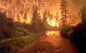
Many economic impacts occur in agriculture and related sectors, because of the reliance of these sectors on surface and groundwater supplies. In addition to losses in yields in both crop and livestock production, drought is associated with insect infestations, plant disease, and wind erosion. The incidence of forest and range fires increases substantially during extended periods of droughts, which in turn places both human and wildlife populations at higher levels of risk. Income loss is another indicator used in assessing the impacts of drought. Reduced income for farmers has a ripple effect. Retailers and others who provide goods and services to farmers face reduced business. This leads to unemployment, increased credit risk for financial institutions, capital shortfalls, and eventual loss of tax revenue for local, state, and federal governments. Prices for food, energy, and other products increase as supplies are reduced. In some cases, local shortages of certain goods result in importing these goods from outside the drought-stricken region. Reduced water supply impairs the navigability of rivers and results in increased transportation costs because products must be transported by alternative means. Hydropower production may also be significantly affected.
Environmental losses are the result of damages to plant and animal species, wildlife habitat, and air and water quality; forest and range fires; degradation of landscape quality; loss of biodiversity; and soil erosion. Some of these effects are short-term, conditions returning to normal following the end of the drought. Other environmental effects last for some time and may even become permanent. Wildlife habitat, for example, may be degraded through the loss of wetlands, lakes, and vegetation. However, many species eventually recover from this temporary aberration. The degradation of landscape quality, including increased soil erosion, may lead to a more permanent loss of biological productivity.
Social impacts involve public safety, health, conflicts between water users, reduced quality of life, and inequities in the distribution of impacts and disaster relief. Many of the impacts identified as economic and environmental have social components as well. Population migration is a significant problem in many countries, often stimulated by a greater supply of food and water elsewhere. Migration is usually to urban areas within the stressed area, or to regions outside the drought area. Migration may even be to adjacent countries. When the drought has abated, the migrants seldom return home, depriving rural areas of valuable human resources. The drought migrants place increasing pressure on the social infrastructure of the urban areas, leading to increased poverty and social unrest. |
| 3. CHARACTERISTICS OF DROUGHT |
|
The characteristics of droughts are expressed in terms of: (1) drought index, (2) intensity-duration-frequency.
A drought index assimilates thousands of data on rainfall, snowpack, streamflow and other water-supply indicators into a comprehensible picture. A drought index is typically a single number, far more useful than raw data for decision making. There are several indices that measure how much precipitation for a given period of time has deviated from historically established norms. Some indices are better suited than others for certain uses. For example, the Palmer Drought Severity Index (PDSI) has been widely used by the U.S. Department of Agriculture to determine when to grant emergency drought assistance. The PDSI is better suited for large areas with uniform topography. Western states, with mountainous terrain and the resulting complex regional microclimates, find it useful to supplement the PDSI with other indices such as the Surface Water Supply Index (SWSI), which takes snowpack and other unique conditions into account. The National Drought Mitigation Center is using a new index, the Standardized Precipitation Index (SPI), to monitor moisture-supply conditions. The distinguishing features of this index are that it identifies emerging droughts months sooner than the Palmer Index, and that it is computed on various time scales. Most water-supply planners find it useful to evaluate one or more indices before making a decision. Important drought indices used in the United States and elsewhere (Australia) are detailed below.
The percent of normal precipitation is the ratio of actual to normal precipitation for a given location and a given period, expressed as a percentage. Analyses using the percent of normal are effective when used for a single region and a single season. In other applications, the index can vary depending on the choice of period, including monthly, seasonal, or annual.
The Standardized Precipitation Index (SPI) was developed in the understanding that a certain deficit of precipitation has different impacts on the soil moisture, ground water, reservoir storage, snowpack, and streamflow. The SPI was designed to quantify the precipitation deficit for multiple time scales. These time scales reflect the impact of drought on the availability of the various types of water resources. Soil moisture conditions respond to precipitation anomalies on a relatively short scale, while ground water, streamflow, and reservoir storage reflect long-term precipitation anomalies. For these reasons, the SPI was originally calculated for 3-, 6-,12-, 24-, and 48-month time periods. The SPI is an index based on the precipitation record for a location and chosen period ( months or years). The record is fitted to a probability distribution which is then transformed into a normal distribution so that the mean SPI for the location and period is zero. The index is negative for drought, and positive for non-drought conditions. Table 1 shows a classification system linking SPI's with drought intensities. A drought event occurs any time the SPI is continuously negative and reaches an intensity less than or equal to -1.0. The event ends when the SPI becomes positive. Each drought event has a duration defined by its beginning and end, and an intensity for each month that the event lasts. The sum of the SPI's for all the months within a drought event is the drought magnitude.
In 1965, Palmer developed an index to measure the departure of the moisture supply.
Palmer based his index on the supply-and-demand
concept of the water-balance equation, taking into account of
precipitation deficit. The objective of the
Palmer Drought Severity Index (PDSI) is to provide standardized
measurements of moisture conditions, so
that comparisons can be made between locations and between durations. The PDSI is a meteorological drought index that is responsive to abnormal weather conditions, either on the dry or wet side. For example, when conditions change from dry to normal or wet, the drought measured by the PDSI ends without taking into account streamflow, lake and reservoir levels, and other long-term hydrological aspects. The PDSI is calculated based on precipitation and temperature data, as well as the local Available Water Content (AWC) of the soil. From the inputs, all the basic terms of the water balance equation can be determined, including evapotranspiration, soil recharge, runoff, and moisture loss from the surface layer. Human impacts on the water balance, such as irrigation, are not considered.
Palmer developed the PDSI to include the duration of a drought or a wet spell.
An abnormally
wet month in the middle of a long-term drought should not have a major impact on the
index, or a series of months with near-normal precipitation
following a serious drought does not mean that the drought is over. Therefore, Palmer
developed criteria for determining when a drought or a wet
spell begins and ends, and to adjust the PDSI accordingly. In near-real time, Palmer's
index is no longer a meteorological index but becomes a
hydrological index, properly referred to as the Palmer Hydrological Drought Index (PHDI). This index
is based on moisture inflow (precipitation), outflow,
and storage, and does not take into account the long-term trend.
The Surface Water Supply Index (SWSI) complements the Palmer Index for moisture condition.
The Palmer Index is basically a
soil-moisture algorithm calibrated for relatively homogeneous regions. It is not
designed for large topographic variations across a region and it
does not account for snow accumulation and subsequent runoff.
The SWSI was designed to be an indicator of surface water conditions, including
mountain snowpack.
The objective of the SWSI is to incorporate both hydrological and climatological
features into a single index resembling the Palmer Index, and applicable to
major river basins. The SWSI values are standardized to allow comparisons between basins.
Four inputs are required: snowpack, streamflow, precipitation, and
reservoir storage. The SWSI is dependent on the season; therefore, it
is computed with only the snowpack, precipitation, and reservoir storage in the winter.
During the summer months, streamflow replaces snowpack as a
component of the SWSI.
The procedure to determine the SWSI for a particular basin is as follows.
Monthly data are collected and summed up for all precipitation stations,
reservoirs, snowpack and streamflow measuring stations across the basin. Each summed
component is normalized using a frequency analysis gathered
from a long-term data set. The probability of nonexceedence
is determined for each component based on the frequency analysis.
This allows comparisons of the probabilities between the components.
Each component has a weight assigned to it depending on its typical
contribution to the surface water within that basin. These
weighted components are summed to determine a SWSI value representing the entire basin.
Like the Palmer Index, the SWSI is centered on zero and has a
range between -4.2 and +4.2.
The Reclamation Drought Index (RDI) was developed as a tool for defining
drought severity and duration, and for predicting the beginning
and end of a drought period. As with the SWSI, the RDI is calculated at a river basin level. It incorporates the supply components of precipitation, snowpack, streamflow, and reservoir levels. The RDI differs from the SWSI in that it builds a temperature-based demand component and a duration into the index. The RDI is adaptable to each particular region and its main strength is its ability to account for both climate and water supply factors. As shown in Table 3, the RDI values and severity designations are similar to the SPI, PDSI, and SWSI.
Another drought-monitoring technique consists of arranging the monthly precipitation data into deciles. This technique was developed to avoid some of the weaknesses of the "percent-of-normal" approach. The technique divides the distribution of occurrences over a long-term precipitation record into tenths of the distribution. Each of these categories is a "decile." The first decile is the rainfall amount not exceeded by the lowest 10% of the precipitation occurrences. The second decile is the precipitation amount not exceeded by the lowest 20% of occurrences. These deciles continue until the rainfall amount identified by the tenth decile is the largest precipitation amount within the long-term record. By definition, the fifth decile is the median, and it is the precipitation amount not exceeded by 50% of the occurrences over the period of record. The deciles are grouped into five classifications.
The relations between drought intensity, duration and frequency can be studied with conceptual models. The conceptual model deals with meteorological droughts lasting at least one year, with specific applicability to subtropical and midlatitudinal regions. The climate types are defined across the climatic spectrum in terms of the ratio of mean annual precipitation to annual global terrestrial precipitation Pma / Pagt , and additionally, on the ratio of annual potential evapotranspiration to mean annual precipitation Eap / Pma . To complete the description, the length of rainy season Lrs across the climatic spectrum is also indicated. Drought intensity is defined as the ratio of the deficit (Pma - P) to the mean (Pma) . For drought events longer than one year, intensity is the summation of the annual intensities. The conceptual model of drought intensity-duration-frequency is shown in Table 5. | ||||||||||||||||||||||||||||||||||||||||||||||||||||||||||||||||||
| 4. DROUGHT MITIGATION |
|
Drought is a natural hazard, it has a slow onset, and
it evolves over months or even years. It may affect a
large region and causes little structural damage.
The impacts of drought can be reduced through preparedness and mitigation.
The components of a drought preparedness and mitigation plan are the following:
Prediction can benefit from climate studies which use coupled ocean/atmosphere models, survey of snow packs, anomalous circulation patterns in the ocean and atmosphere, soil moisture, assimilation of remotely sensed data into numerical prediction models, and knowledge of stored water available for domestic, stock, and irrigation uses. Monitoring exists in countries which use ground-based information such as rainfall, weather, crop conditions and water availability. Satellite observations complement data collected by ground systems. Satellites are necessary for the provision of synoptic, wide-area coverage. Impact assessment is carried out on the basis of land-use type, persistence of stressed conditions, demographics and existing infrastructure, intensity and areal extent, and its effect on agricultural yield, public health, water quantity and quality, and building subsidence. Response includes improved drought monitoring, better water and crop management, augmentation of water supplies with groundwater, increased public awareness and education, intensified watershed and local planning, reduction in water demand, and water conservation. Drought preparedness and mitigation can be accomplished with the following practices: (1) soil and water conservation, and (2) herd management. 4.1 Soil and Water Conservation Conservation practices minimize the disruption of the soil's structure, composition and natural biodiversity, thereby reducing erosion and soil degradation, surface runoff, and water pollution. The following are established practices of soil and water conservation:
Contoured rowcrops Terracing Tillage practices Erosion-control structures Water retention and detention structures Windbreaks and shelterbelts Litter management Reclamation of salt-affected soil.
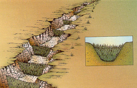
Soil and water conservation can be approached through agronomic and engineering measures. Agronomic measures include contour farming, off-season tillage, deep tillage, mulching and providing vegetative barriers on the contour. These measures prevent soil erosion and increase soil moisture. Engineering measures differ with location, slope of the land, soil type, and amount and intensity of rainfall. Measures commonly used are the following:
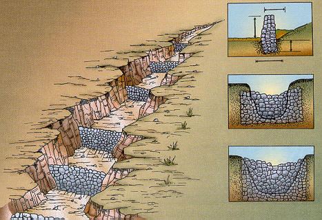
Contour bunds, trenches and stone walls. These features prevent soil erosion and obstruct the flow of runoff. The retained water increases soil moisture and recharges the groundwater. Check dams and other gully-plugging structures. Check dams are temporary structures constructed with locally available materials. Types of check dams are the brush-wood dam (Fig. 2 a), the loose-rock dam (Fig. 2 b) and the woven-wire dam. Percolation ponds. These features store water for livestock and recharge the groundwater. They are constructed by excavating a depression to form a small reservoir, or by constructing an embankment in a natural ravine or gully to form an impoundment.
Water-supply projects can also be implemented for drought mitigation, with a view to strengthen drought preparedness. Activities such as water-use planning, rain-water harvesting, runoff collection using surface and underground structures, improved management of channels and wells, exploration of additional water resources through drilling and dam construction, are implemented as a part of a drought-mitigation plan. To increase moisture availability, the following in-situ moisture-conservation practices can be adopted:
For tree crops, measures include saucer basins (Fig. 3), semi-circular bunds, crescent-shaped bunds, V-ditch technology, catch pits and deep pitting. Rainwater harvesting collects rainfall or moisture for immediate or eventual use in irrigation or domestic supplies. Part of the rainwater collected from roofs can be stored in a cistern or tank for later use. Landscape contouring is used to direct runoff into areas planted with trees, shrubs, and turf.
Farmers can prepare for drought by developing plans which cover all aspects of farm management and take into account variable climatic conditions. Sustainable strategies include appropriate fencing to control overgrazing, pest-control measures, planting drought-resistant crops and pasture, stabilization of eroded soils, pruning plants to reduce leaf area, removing weak plants and thinning dense beds to reduce competition, and the protection of native plant species.
4.2 Herd management Herd management is an important strategy for drought mitigation. Factors to be considered include the expected drought duration, the current water and feed supplies, the composition and body condition of the herd, and the financial resources available.
Herd management practices include the following:
Reduction in herd numbers When feed resources are getting short, one solution is to critically evaluate the members of the herd and eliminate those that are less useful. Sale or agistment (relocating herd to non-affected pastures) are the two options available to reduce stock numbers. Strategic weaning of calves During a drought, the production of milk rapidly depletes a cow's body reserves, while the calf derives little benefit. Weaning the calf gives the cow a better chance of survival. However, the decision to wean must be made in relation to the time of year and age of the calf. In normal years, the nutritive value of pasture falls towards the end of autumn, at which time, beef cows may be producing as little as 1 liter of milk per day. If the calf is 5 to 6 months of age, weaning by the end of autumn will maintain or improve the cow's condition. In drought years, early weaning is recommended. However, calves should not be weaned before 3 months of age unless absolutely necessary. Young calves need to be fed some true protein meal or preferably milk powder. Most calves over three months of age will survive on grain and Lucerne hay or molasses and protein meal diets. Herd segregation Segregating animals into classes gives the herd a better chance of getting needed feed supplies. Segregation makes possible the preferential treatment of vulnerable classes. The older dry cows can be moved to the poorer forage fields. Pregnancy testing is a useful tool to identify heavily pregnant cows for special feeding, especially young cows that are pregnant for a second time. Parasite control Cattle under nutritional and other stresses are less resistant to parasites than in normal conditions. Worms can be a serious problem with young cattle. During drought conditions, all cattle under 18 months of age should be treated for worms. Optimizing use of drought-affected paddock Cattle do not graze well areas located far away from watering points. Use of a drought-affected paddock can be encouraged by providing local water facilities, with supplementary hand feeding as an attractant. Attention to contaminated water supplies Polluted surface waters represent a death trap for drought-weakened cattle. Fencing may be necessary to separate cattle from undesirable water holes. Salinity may increase with the depletion of the water table, with the water becoming too salty for the herd. The upper limit of total soluble salts should not exceed 8500 ppm. In addition, the sum of chlorides and sulphates of calcium and magnesium should not exceed 1400 ppm. Potential problems arising from drought conditions are:
Over consumption of urea-containing supplements by cattle grazing on forage-scarce ranges can result in urea toxicity. Generally, performance of cattle on urea-type supplements is poor wherever forage is in short supply. Hay cut under moisture-stress conditions, especially sorghum-type hays, may contain high levels of nitrate. Tests for nitrate should be performed before feeding these hays, especially before feeding large amounts. Farmers who cut drought corn or sorghum for hay should check nitrate levels before feeding. Prussic acid or cyanide poisoning can be a problem in grazing drought-stunted plants such as Johnson grass, sorghum, sorghum hybrids, and sudan grass. Prussic acid is generally not a problem when forage for hay is allowed to sun cure for 3 to 5 days, in order to bleach out any bright green color. Cattle that graze short or drought-stunted pasture are more likely to consume toxic plants.
|
| 5. APPLICATION TO THE OJOS NEGROS VALLEY, BAJA CALIFORNIA, MEXICO |
|
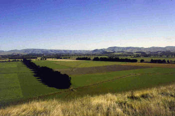
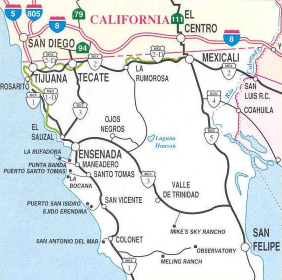
The Ojos Negros valley is located in the state of Baja California, Mexico, approximately 40 km east of Ensenada, along the Mexico 3 highway.
The valley has an arid climate, with rainy season in the winter (November to April) and extreme temperature variability.
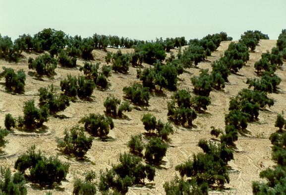
Agriculture and animal husbandry are the primary economic activities in the valley. The valley has approximately 3000 ha under irrigation,
and about 5000 head of cattle.
The irrigated agriculture is supported by groundwater;
however, a sizable portion of the total cultivated area is operated by
dryland farming, and consequently, it is subject to droughts. Droughts are a recurrent feature
of the landscape, primarily affecting the dryland farming and related animal-husbandry operations.
The climatological records for ten (10) stations located in Baja California, in the vicinity of the Ojos Negros valley, were analyzed to establish drought intensity-duration-frequency relations following the conceptual model described above. The results of the analysis are shown in Table 6. |
|
While the average drought intensity for all stations is 0.83 (moderate), the intensity at Ojos Negros is 1.23 (severe).
This shows that drought intensity is likely to be severe in the immediate vicinity of the Ojos Negros valley, while
remaining moderate for the rest of the study region. The average drought duration is 2.0 yr at Ojos Negros, and 2.44 yr for the region;
the average drought frequency is 3.54 yr at Ojos Negros, and 3.96 yr for the region. It is concluded that droughts in the
Ojos Negros valley and vicinity are moderate to severe, they recur every 3-4 yr, and they last about 2 yr.
Strategies for coping with droughts in the Ojos Negros valley include drought preparedness and mitigation. The following strategies have been identified:
In principle, herd numbers should be related to the climate. The local climate is subject to variability, and the dry periods (droughts) may last more than one year. In the Ojos Negros valley in particular, drought is likely to be moderate to severe, last 2 yr, and recur every 3-4 yr. Therefore, ranchers must consider this climatic constraint when planning the size of their herds. In general, herds should expand during periods of wet weather, and contract during drought periods. Forecasting the climate on an annual basis is the responsibility of the national water agency. During a drought, the herd manager should evaluate the members of the herd to eliminate the inefficient individuals. The herd size should be reduced to a number that can be supported by the available resources. The physical attributes of the individual animals should be evaluated critically. Animals with bad physical attributes or diminished reproduction ability should be considered for culling. The replacement heifer crop should be critically evaluated. In a drought year, the minimum number of heifers should be retained, and the rest should be sold. Bull should be evaluated to select those that are getting old and in need of replacement. Old bulls should be eliminated during drought years, and replaced as soon as practicable. All cattle are affected by a host of internal and external parasites. Cattle under nutritional and heat stress are less resistant to parasites than under normal conditions. Strategic deworming during a drought will relieve some of the nutritional stress on the animals. Heifers and calves are not able to compete with mature cattle for pasture or supplemental feed. Drought feed is costly and it is important to feed only those animals who really need it. Segregating animals gives each class a better chance of getting needed feed supplies. Vulnerable classes can be segregated and given preferential treatment. The older dry cows can be moved to the poorer forage fields. Contract grazing or renting pasture is another drought strategy. However, the cost of hauling or renting the pasture should not be more than the cost of purchasing feed. Use of a drought-affected paddock can be optimized by providing local water facilities and supplemental hand feeding.
Water retention and detention structures capture storm-water runoff which can be used for a variety of purposes, including groundwater recharge, irrigation, and drinking water for livestock. Windbreaks and shelterbelts help in reducing wind velocity and, therefore, evaporation and evapotranspiration, aiding in coping with drought. Rainwater harvesting can be accomplished for immediate or eventual use in irrigation or drinking water for livestock. Landscape contouring and terracing can be implemented where feasible to reduce runoff and direct excess moisture into areas planted with trees, shrubs, and grass. |
| 6. SUMMARY |
|
Droughts are a recurrent feature of the climate. Droughts vary in intensity, duration, and frequency across the climatic spectrum. A drought can have substantial economic, environmental, and social impacts. The Ojos Negros valley, in Baja California, Mexico, has an arid climate, and is, therefore, subject to frequent droughts. Agriculture and animal husbandry are the primary economic activities in the valley. Agriculture is entirely supported by groundwater, while animal husbandry is primarily supported by dryland farming. Drought intensity varies from severe in the Ojos Negros valley (1.23) to moderate across the region (0.83). Drought duration varies from 2 yr in the Ojos Negros valley to 2.44 yr in the region. Drought frequency varies from 3.54 in the Ojos Negros valley to 3.96 yr in the region. Herd management is an appropriate strategy for drought mitigation. Appropriate herd management in Ojos Negros can help reduce the impact of drought. Soil-and-water conservation is an established practice for drought preparedness and mitigation. Soil-and-water conservation practices in the Ojos Negros valley and surrounding areas can help mitigate the impacts of droughts.
|
| 020130 | http://ponce.sdsu.edu/protected2/droughtdatasheet.html |