|
|

|
| Google Earth (2007) |
|
HYDROLOGICAL AND ENVIRONMENTAL IMPACT January 2008
• INTRODUCTION •
The Vitor Valley, located 955 km south of Lima, near Arequipa, Peru, is being threatened by hydrological and environmental impacts which can be directly attributed to the neighboring irrigation. The irrigation projects, specifically La Joya and San Isidro-La Cano, have been developed by the government to bring into economic productivity the extensive overlying flatlands, which lack water under natural conditions. The impacts are of two types: (1) the increase in the salinity of the river water, after receiving irrigation return flows, and (2) the slides in the valley slopes, as a result of the destabilization produced by the uncontrolled drainage of the return flows. The problem is serious because it may result in the degradation of the agricultural activity in the downstream valleys (Vitor and Quilca). The increase in the concentration of dissolved salts in the irrigation water limits the type of crop and decreases its productivity. The slope slides may compromise areas that were previously part of the valley, causing substantial damage to local farmers. In some cases, the soil and rocks mobilized by the slides may reach the hydraulic section of the river, which is then forced to transport the materials during floods, depositing them downstream as the river loses its carrying capacity (Fig. 2). The result is the widening and aggradation of the affected river, increasing the risk of flooding. The impact is gradual, usually taking several decades to develop. Furthermore, the effects may be observed in places that are quite distant from the source of the problem. By way of comparison, Walters (1975) has described the impact of massive bank caving on the Lower Mississippi river, as a direct result of the 1811-12 New Madrid, Ohio, earthquake.
Fig. 2 In the Punillo sector of La Cano, the slope slide is next to the river. There is an urgency to mitigate these problems, because the social and economic costs could be very high. The problem is of an interdisciplinary nature, with geological, geomorphological, hydrogeological, geotecnical, and irrigation/drainage aspects. In addition, the problem has a marked social and economic component, because the irrigation projects involve a variety of stakeholders and represent an important source of income in the region. This report is the result of a visit to the Vitor Valley and environs during the week of June 26 to July 3, 2007. The report represents an effort to understand and eventually mitigate the hydrological and environmental impacts of the irrigations of La Joya and San Isidro-La Cano on the Vitor valley. At the outset it is recognized that the problem is not restricted to the Vitor valley, since other neighboring valleys such as Majes-Siguas are known to be experiencing similar problems. The objective is twofold: (1) to understand the interdisciplinary nature of the problem, and (2) to develop a methodology to predict similar problems in the future, in Arequipa as well as in the rest of Peru and the world. • BACKGROUND •
The southern coast of Peru, particularly the department of Arequipa, contains numerous sedimentary formations of Tertiary and Pleistocene origin (Flores and Maggiolo, 1975). These formations are characterized by a relatively smooth and slightly undulating morphology, which has rightly deserved them the name of "pampas." In addition, they contain a large amount of salts, which reveals a probable marine origin (Sébrier et al, 1988; Saillard et al, 2007). During the Cuarternary Period, these formations were cut by several streams descending from the Andes, among which are the Chili-Vitor-Quilca and Colca-Majes-Camana. After flowing through Arequipa, the Chili river joins the Yura river near Palca to form the Vitor river. Later, the Vitor river joins the Siguas to form the Quilca, which flows towards the Pacific Ocean. The difference in elevation between the Vitor valley and the overlying pampas is 220-260 m (Fig. 3). The irrigated fields of La Joya and San Isidro-La Cano are located in the pampas adyacent to the Vitor valley, along the left margin.
Fig. 3 Slide at Pie De Cuesta, showing the elevation difference (260 m) between the pampas and the Vitor valley.
Agriculture in the valleys of the Peruvian southern coast, among them, the Vitor valley, is very old, probably going back to pre-Hispanic times. More recently, starting in the 1940s, the Peruvian government has supported the irrigation of the overlying pampas, for the purpose of making the desert economically productive. The irrigation projects of La Joya and San Isidro-La Cano, among others, are the result of these efforts. The agricultural development of the pampas of the Peruvian southern coast can be encapsulated in the following observations:
Fig. 4 Ongoing slide in the Punillo (La Cano) section of the Vitor valley, at 12:30 p.m., June 29, 2007. The social challenge is how to carry out the irrigation, while simultaneously mitigating the associated hydrological and environmental impacts. The increase in the salinity of the surface waters does not seem to have an economically viable solution. It can be mitigated with the treatment of return flows and appropriate disposal of brines. The slope slides can be mitigated with the use of systems that minimize the uncontrolled drainage of irrigation return flows. The solution of these problems will require enormous resources, in addition to the consensus of local stakeholders and a good dose of political will at all levels of government. The alternative is stalemate, and the consequent environmental and socioeconomic deterioration of the regions located downstream of the irrigation projects.
• HISTORY •
In the department of Arequipa, the irrigations of La Joya and San Isidro-La Cano, among others, have been producing a series of hydrological and environmental impacts on the neighboring Vitor valley. Apparently, these impacts were not identified during planning and construction of the irrigation projects, showing up only after many years of operation. A significant impact is the progressive deterioration in the quality of the surface waters. This is due mainly to the leaching of the salts naturally contained in the geologic profile, salts that are dissolved in the irrigation return flows. In La Joya, these processes of drainage and contamination of surface waters began in 1940, and in San Isidro-La Cano in 1975. The deterioration of the water quality in the Vitor river appears to be quite marked. Measurements of electrical conductivity show an increase of almost 600%, from 1.1 dS/m upstream, in the Palca sector, to 6.0 dS/m downstream, in the Santa Rosa sector (Fig. 4) [dS/m = deciSiemens/m; 1 dS/m = 1 mmho/cm]. Along the left margin, within the area of influence of La Joya (Mocoro, Gallinazos, and Pie de Cuesta), the measurements of electrical conductivity vary from 1.5 to 4.3 dS/m. It should be mentioned that sensitive crops usually start experiencing reductions in productivity when the electrical conductivity of the water exceeds 1.5 dS/m.
in the Vitor valley, August 1992.
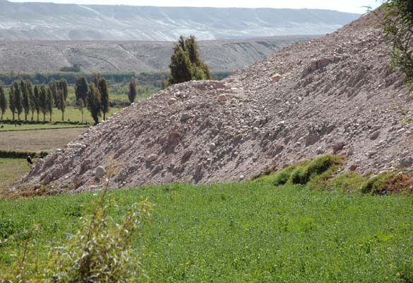
According to credible eyewitnesses, the water percolations in the slopes neighboring La Joya, particularly at Pie de Cuesta, began around 1956. In time, they sustained the establishment of riparian communities, which can be observed in many places along the slopes (Fig. 3). Eventually, the percolations concentrated into individual watercourses, which come down the slope at great speed and increase, directly or indirectly, the flow of the Vitor river. The slide at Pie de Cuesta began on October 6, 1974, apparently at the same time as an earthquake which rattled Arequipa. The greater collapse occurred on January 9, 1975, almost simultaneously with another smaller slide at the nearby Gallinazos Creek. The slide buried the school and several dwellings, and it stopped short of burying the local church. It also covered six hectares of the irrigated area of the valley. It is not known with certainty if this slide is currently stable or in movement. Nevertheless, it is estimated that it has already compromised nearly 20% of the original width of the valley (Fig. 1). If the movements continue, it could eventually cover the entire width, with serious hydrological and environmental consequences. It should be mentioned that the slide at Pie de Cuesta interrupted and rendered inoperable the original La Cano irrigation canal, which conveyed surface waters taken directly from the Vitor river. The present La Cano canal intakes irrigation return flows from La Joya at San Luis Creek, conveying them towards the pampas of San Isidro-La Cano (Fig. 6).
Fig. 6 The La Cano main irrigation canal.
In 1978, in the La Cossío sector of the Vitor valley, the slopes began to show signs of wetting, and small slides began to develop. These slides were followed in 1984 by a great collapse. In 1985, the sector Santa Rosa sector experienced similar problems. In the Punillo sector, the wetting began in 1986, and in November 1994, a great slide took place, which overtook the Vitor river channel, forcing it to change course and move into the lands on its right margin. In July 2007, many slides took place in the area of the Vitor valley neighboring the La Cano sector (Fig. 4). These slides are generally small, but their apparent regularity is a cause for concern. According to local people, the intense geodynamic activity began recently, around the middle of June 2007. Given the present circumstances, it can be concluded that the slopes of the Vitor valley, particularly those of the left margin, are in an active geodynamic process, and that it is very probable that the causes are anthropogenic. • VISIT •
During the week of June 26 to July 3, 2007, the author made several visits to the Vitor valley, specifically to document the slides at Pie de Cuesta and La Cano. The first visit was on June 27 to Pie de Cuesta, where a major slide occurred in 1975. The second visit was on June 29 to Mocoro Creek, the La Cano sector, and the intake to La Cano canal. During this visit, the author observed several slides in progress, specifically in the La Cano sector. This observations were taken from the bottom of the slope, on the Vitor valley floor. The third visit was on July 1, to the area of La Cano where the slides have been taking place. The observations of this last visit were made from the top, from the perspective of the pampas. In the first visit, the size of the slide at Pie de Cuesta, which occurred on January 1975, was documented (Fig. 1). Currently the slide covers about six hectares of land which previously formed part of the valley (Fig. 7). The slide also covered a few dwellings, which have been abandoned. It is not known with certainty if the slide is active. Local people believe that the slide is active, and it is presumably so, but precise measurements to confirm this hypothesis are not available.
Fig. 7 Panoramic view of the slide at Pie de Cuesta, Vitor valley. In the second visit, the percolations produced by the return flows of La Joya were observed in Mocoro Creek. The visit included observations on June 29, 2007, precisely at the time when several slides were taking place in the Punillo sector of La Cano. Three slides were observed within a period of forty minutes. These were characterized by large clouds of dust created during the fall of the soil material, from the top of the slopes towards the bottom, close to the valley floor (Fig. 4). The visit included an inspection of the intake of the La Cano canal, which takes the return waters of La Joya at San Luis Creek, conveying them towards San Isidro-La Cano (Fig. 13). During the third visit, on July 1, 2007, new slides were observed on La Cano slopes, this time from the top. Apparently the slides are occurring with sufficient regularity, because several of them were observed during the days of the visit, both on June 29 and July 1. The condition of the slopes was observed at short range, and it was concluded that they are in an active geodynamic state. Several portions of the slope are in imminent failure mode (Figs. 9 and 10). In this area, the pampas are at elevation 1,307 m while the adjacent river is at 1,081 m, which results in a total slope height of 226 m. A sizable lagoon could be seen at approximately mid-slope elevation, and a smaller one in the vicinity (Fig. 8). It is very likely that the water in these lagoons originates in return flows from San Isidro-La Cano.
Fig. 8 Mid-slope lagoons originating in return flows from the Punillo sector of San Isidro-La Cano. The field observations confirm that there is a serious slide problem on the Vitor valley slopes, particularly in the La Cano sector. The cause of these slides may be attributed to the irrigation return flows. The difference in elevation between the pampas of La Joya and La Cano on the one hand, and the Vitor valley floor on the other hand, is approximately 220-260 meters. The irrigation system being used, mainly gravity fed, causes a considerable loss of water. In finding its most natural path toward the oceans, this water comes into contact with the steep slopes, affecting their mechanical stability and resulting in the slides. The anthropogenic root of this geodynamic problem demands a thorough evaluation, and eventually a project that will result in effective measures to mitigate the negative impacts. The studies must encompass several fields, among which the most important are: (1) geology and geomorphology, (2) hydrogeology, (3) geotechnical engineering, and (4) irrigation and drainage. • STUDIES •
There is a need for a strategy to mitigate the negative hydrologic and environmental impacts of the irrigations of La Joya and San Isidro-La Cano on the Vitor valley. Since the irrigation projects are currently under operation, it is not envisioned that they will cease. Therefore, the solution lies elsewhere, specifically in the eventual control of the flow that currently drains toward the slopes. The problem at La Cano appears pressing enough, and must be handled with utmost care. Also, there are water relations worth considering, since La Joya return flows are currently serving a useful purpose in La Cano. The geologic and geomorphologic studies must review all the existing knowledge on the pampas, their genesis, stratigraphy, and geologic properties. The objective is to determine with sufficient certainty the predominant stratigraphy, to enable an evaluation of the possible conduits of natural drainage. The salinity of the various layers, both superficial and deep, must be evaluated with the purpose of serving as baseline to an eventual design. The geologic mapping of the pampas of La Joya and San Isidro-La Cano must be the primary target of this component of the study. To a certain extent, the exposed slope along the left margin of the Vitor valley may be used as an indicator of the geology and stratigraphy of the adjacent pampas (Fig. 14). The hydrogeologic study must document the presence of the water table, before and after irrigation, that will allow evaluation of the groundwater flow and the effect that this may have on the slides (Fig. 9). Special care should be taken to evaluate the characteristics of the unsaturated, or vadose, zone, and the effect that the stratifications may have in the overall direction of groundwater flow.
Fig. 9 Slide in progress at the Punillo sector of La Cano, on July 1, 2007. The geotechnical studies must establish the factor of safety of the slopes, in the Pie de Cuesta sector where the slides appear to be stable, and in the La Cano sector where intense geodynamic processes have been observed in recent days. The material, a conglomerate (gravel) in a matrix of fine sand with silt, could lose its shear strength under certain conditions of deposit, cementation, or wetting (Rollins, et al., 1994, 1995; Day, 1995; Fernandez, 1997). The geotechnical studies may also seek to consider the eventual stabilization of the slope, after corrective measures have been taken to reduce the flow towards the slopes. The irrigation and drainage studies must focus on controlling the volume of drainage towards the slopes. This can be accomplished by the replacement of the existing gravity-fed system by a drip-irrigation system. It should be noted that drip irrigation substantially reduces the amount of leaching, but it does not eliminate it. In any case, excess salts must be leached out of the soil profile in order to sustain the agricultural enterprise. Thus, there will always be a certain amount of drainage water, which will have to be handled in the most thoughful way. For this purpose, a drainage system may be considered, to collect the return flow of the pampas, particularly those of La Cano, and convey it downstream in a controlled manner, without compromising the stability of the neighboring slopes (Fig. 10).
Fig. 10 Imminent slide and in progress on the Punillo sector of La Cano, July 1, 2007. The change in the irrigation system, from gravity fed to drip, involves many technical, social, and economic considerations. The solution must be integral, achieved through consensus with local growers, and totally or partially financed by the central and regional governments, with the asistance of multilateral banks such as the Inter-American Development Bank (IDB). The overall objective should be to stop the slides; otherwise, the problem will become untenable in the medium and long term. The impact of the increase in salinity must be documented by a program of measurements of water quantity and quality. The tendency to an increase in the salinity of the surface waters must be monitored carefully, with the purpose of informing downstream users (Fig. 5). The historical tendencies in the salinity of the Vitor-Quilca river must be documented thoroughly. • SOLUTIONS •
On a preliminary basis, the following measures are considered to mitigate the hydrologic and environmental impacts of the irrigations of La Joya and La Cano on the Vitor valley. The first measure is the drainage of the irrigated pampas, with the purpose of conveying the larger flows already established (in the past), and the smaller flows to develop in the future (a certain amount of leaching will always be necessary) by engineered drainage conduits. This solution is expensive and failure-prone, and will require the consensus of local growers, including a good measure of political will. The second measure consists of the stabilization of the slope to eliminate the failures. This solution may be expensive because the overall height of the slope is approximately 220-260 meters (Fig. 11). An alternate way to stabilize the slope would be to build a drain, parallel to the slope, that collects the return flows and conveys them out of harm's way.
Fig. 11 Unstable slope in the Punillo sector of La Cano, Vitor Valley. It should be mentioned that at the moment there does not exist, from a local perspective, a solution to the problem of the increase in salinity of surface waters as a result of contamination with irrigation return flows. The treatment of saline waters is very expensive, and a by-pass toward the ocean, practiced in regions such as Guyana, would generally prove to be cost prohibitive. In addition to the engineering solutions, there is an agronomic solution which must be given some consideration. It consists of the eventual replacement of the traditional crops, like alfalfa and vegetables, by the intensive cultivation of the cactus (Opuntia ficus-indica) that sustains the parasitic insect cochineal (Dactylopius coccus) [woodlouse, or cochineal]. However, decisions to convert to cochineal must consider the economic constraints (the fluctuating price of the crop in the international markets). In most cases, the agroindustrial production of cochineal appears to be very profitable (Flores, 1995). In addition, some cochineal growers state that the product is of higher quality when the irrigation is made with saline waters, a statement which requires additional research. Properly conceived and executed, the gradual change towards the binomial cactus/cochineal may possibly result in the partial solution to the slide problem. • CONCLUSIONS •
The visit to the Vitor Valley and environs, in the week of June 26 to July 3, 2007, has enabled the following conclusions:
Fig. 12 Front face of the slide at Pie de Cuesta, Vitor valley. • APPENDIX: THE ORIGIN OF THE SALTS •
From an agricultural point of view, the management of salinity in soil and water is a problem which has no easy answer (American Society of Civil Engineers, 1990). Soils and waters that are naturally saline, and/or those that they been salinized by anthropogenic action, are present in many regions of the world. Prior to the formulation of a management program, it is necessary to know the source, transport, and fate of these salts. Salts originate naturally in the rocks, and through weathering and transport, they move from the lithospere toward the hydrosphere, passing through the biosphere. In the biosphere, the demand for sodium chloride is much smaller than the supply; therefore, this salt usually accumulates and is washed away by runoff toward its final destination, the ocean. It is the purpose of streams and rivers to convey the dissolved salts, from their source in the basins headwaters, toward the oceans. Local and regional geomorphology determine if the salts arrive eventually at the ocean, or if their trip is interrupted and they are stored in endorheic basins (closed basins, i.e., that do not drain into the ocean).
The salts that are present downstream of an irrigation project can be: (a) old or new, and (b) natural or artificial (Ponce, 2006). The old natural salts are those that are present in the soil profiles, in formations which have been subject to insufficient drainage in the geologic past. Such is the case of the existing salts in the pampas of Arequipa. The irrigation of these pampas will produce leaching of the salts, and the eventual salinization of the downstream watercourses.
The old artificial salts are those that are present in the irrigation water. These waters have a geologic origin, but they have been mobilized recently by the irrigation projects. In the present case, these salts are partly contained in the return flow of La Joya, dissolved in the waters of the La Cano canal (Fig. 13).
Fig. 13 Intake of the La Cano canal, in San Luis Creek, downstream of La Joya. The new natural salts are those produced by the weathering of geologically new soil, like those of the pampas of La Joya and La Cano. These desert soils are naturally fertile because they have not been subjected to the washing produced by precipitation. It should be mentioned that the so-called "fertility" of the desert is really a double-edge sword. This is because the agricultural productivity generates, on the one hand, mostly useful salts, like those of potassium and magnesium and, on the other hand, largely useless salts, like sodium chloride. The supply of ions of chloride and sodium greatly exceeds the natural demand of the biosphere; consequently, the surplus is dissolved in the runoff and transported downstream.
The new artificial salts are those produced by an excessive application of fertilizers, which, in extreme cases, can lead to the eutrophication of rivers, lakes, and estuaries, located downstream of the zone of application. Although this occurs in other parts of the world, for example, in Chesapeake bay, USA (U.S. Geological Survey, 2007), apparently it is not the case at La Joya and San Isidro-La Cano.
The irrigation enterprise, defined as an anthropogenic activity that optimizes agricultural productivity with an economic objective, invariably mobilizes and produces an amount of salts, mainly ions of chloride, sulfate, and sodium, sodium chloride and sodium sulfate (American Society of Civil Engineers, 1990). It is incumbent on a well planned project to estimate the quantity and percentage of salts, old/new, and natural/artificial, that will be dissolved in the return waters. The correct management of return flows determines the success and sustainability of an irrigation project.
Fig. 14 Close view of sedimentary formations on the slopes of the Vitor valley. • REFERENCES •
American Society of Civil Engineers. 1990. Agricultural salinity assessment and management. Manuals and Reports on Engineering Practice No. 71, Washington, D.C. Day, R. W. 1995. Discussion to "Identification and characterization of collapsible gravels," by K. M. Rollins, R. L. Rollins, T. D. Smith, and G. H. Beckwith. Journal of Geotechnical Engineering, ASCE, 121(6), 510-511. Fernández, E. 1997. Investigación del conglomerado colapsable de La Cano, Vítor, Arequipa. Master's thesis, Faculty of Civil Engineering, National University of Engineering, Lima, Peru. Flores, V. I. 1995. Crianza de la cochinilla en Sudamérica. En Memorias del Conocimiento y Aprovechamiento del Nopal, 6to. Congreso Nacional y 4to. Internacional, Universidad de Guadalajara, Guadalajara, Jalisco, México, 48-55. Flores, A., and O. Maggiolo. 1975. Reconocimiento geotécnico de la margen izquierda del río Vítor en el sector donde se han producido deslizamientos que afectan al canal de irrigación "La Cano" y al poblado de "Pie de Cuesta." Informe Técnico No. 001-75-IIA-IG, Ministerio de Agricultura, Dirección General de Irrigaciones, Instituto de Investigaciones Aplicadas, Subdirección de Investigaciones Geotécnicas, Febrero, Lima, Perú. Ponce, V. M. 2006. The Salton Sea: An assessment. http://saltonsea.sdsu.edu Rollins, K. M., R. L. Rollins, T. D. Smith, and G. H. Beckwith. 1994. Identification and characterization of collapsible gravels. Journal of Geotechnical Engineering, ASCE, 120(3), 528-542. Rollins, K. M., R. L. Rollins, T. D. Smith, and G. H. Beckwith. 1994. Closure to "Identification and characterization of collapsible gravels." Journal of Geotechnical Engineering, ASCE, 121(6), 511-512. Saillard, M., N. Audin, G. Hérail, S. Carretier, V. Regard, L. Ortlieb, S. Hall, D. Farber, G. Martinod, y J. Macharé. 2007. 10Be and 26Al dating of marine terraces to quantify the uplift of Peruvian and Chilean coastal areas. Geophysical Research Abstracts, European Geosciences Union, Vol. 9, 05013. Sébrier, M., A. Lavenu, M. Fornari, y J. P. Soulas. 1988. Tectonics and uplift in Central Andes (Peru, Bolivia and Northern Chile) from Eocene to present. Géodynamique, 3(1-2), 85-106. U.S. Geological Survey. 2007. Overview of the U.S. Geological Survey Chesapeake Bay Ecosystem Program. http://pubs.usgs.gov/fs/fs12497/ Walters, W. H. 1975. Regime changes of the Lower Mississippi River. M. S. Thesis, Department of Civil Engineering, Colorado State University, Fort Collins, Colorado.
showing the lagoons (Fig 8).
|