-
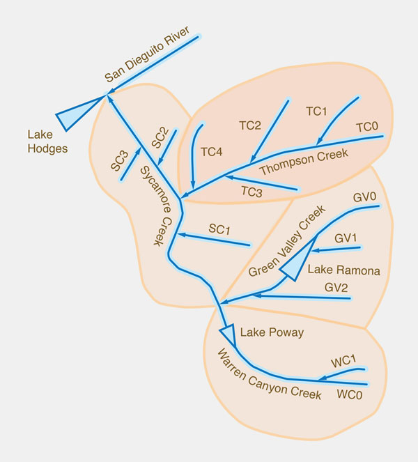
Thompson Creek Groundwater Sustainability Study.
The groundwater resources of Thompson Creek, in Poway, California, are limited and not readily replenishable. Existing hand-dug wells indicate that the water table was higher, i.e., much closer to the surface, prior to the extensive groundwater development of the past 15 to 20 years. Significantly, a spring in Lower Thompson Creek, documented by USGS in the 1980s, is no longer there. Aquifer depletion amounts to as much as 280 feet in certain areas. This amount is large compared with four classic textbook examples of groundwater depletion, which range from 150 to 300 feet.
Over the past 12 years, the average capture-to-recharge percentage in Thompson Creek and vicinity has been 109%. To provide a measure of comparison, the average capture-to-recharge percentage in the continental United States is about 8.7%. Capture of 100% or more of the recharge, with the intent to make maximum use of the available groundwater, has been widely discredited.
The obsolescence of the concept of "safe yield" has cast serious doubts into the practice of using groundwater to support turf irrigation at Maderas Golf Club and other areas. Expert scientific opinion now recommends the determination of a sustainable yield, interpreted as a reasoned, suitable fraction of the recharge. Therefore, the use of groundwater for extensive turf irrigation should be discouraged, or else reduced to an amount consistent with current practices of groundwater sustainability.
All groundwater originates in rainfall; therefore, the documented depletion at Thompson Creek must be because pumping is exceeding replenishment. Since Maderas Golf Club is pumping close to 70% of the total volume, it follows that they must account for about two-thirds of the groundwater depletion in the basin. Capturing an average value of 109% of the gross annual recharge is clearly not sustainable.
-
Comments to the Draft Supplemental Environmental Impact Statement (DSEIS) for the proposed Campo Regional Landfill Project.
This document provides comments to the Draft Supplemental Environmental Impact Statement (DSEIS) for the proposed Campo Regional Landfill Project.
The DSEIS was prepared by the Bureau of Indian Affairs in cooperation with the Campo Band of Mission Indians, the Campo Environmental Protection
Agency, and the U.S. Environmental Protection Agency. This document is organized into various headings. Headings are organized topically to comment on major issues raised by the DSEIS.
The siting of the Campo landfill on top of a fractured rock aquifer, barring appropriate characterization of the fractured rock system, and without
adequate monitoring to prevent contaminant leakage beyond the landfill perimeter, threatens the quality of life of nearby residents, both on and off the reservation.
Subsurface flow direction in a fractured rock aquifer defies characterization and absolute certainty. Thus, aquifer contamination remains a distinct
possibility. Once the groundwater has become contaminated, it will be very difficult to remediate. The contaminated water may tend to diffuse into
the rock matrix's stagnant pore water, increasing the difficulty of cleanup. Another source of concern is the possible mobilization of chemical
elements in the rock, as a result of the biogeochemistry of the leachate plume.
The absence of a detailed plan for east-side well monitoring for nearly two-thirds of the landfill footprint is a serious omission of the DSEIS.
As currently conceived, the plan is expected to provide monitoring wells at a distance of about 500 feet on the east side. This is insufficient and a cause for grave concern.
The federal designation of the Campo-Cottonwood Creek aquifer, which includes the Tierra del Sol aquifer, as sole source means that if this
aquifer becomes contaminated, there are no reasonably available sources of water. Mitigation measures have promised to make up for this, but
no feasible alternative sources have been identified.
Once the state-avowed target of 75% waste diversion is fully in place, the need for additional landfill space in San Diego County will be
significantly reduced for the next several decades. It is highly improbable that the county would need to rely on the Campo landfill for
its solid waste disposal needs well into the future. Therefore, to remain in business, the Campo landfill will have to import waste from
much farther sources and, at that point, may have to consider receiving other types of wastes, including special wastes.
The neglect of the February 24, 1892 earthquake, of Magnitude 7.8, the largest on record, is a serious omission of the DSEIS. The Maximum
Credible Earthquake (MCE) may have to be recalculated. Strong ground motions can reset the pressure in the fractured rock aquifer and can
cause very large temporary increases in water pressure. No liner taking a direct hit can withstand these pressure increases.
In summary, the proposed Campo landfill site lies: (1) on top of a fractured rock aquifer, (2) on a headwater basin where very intense
storms are possible, (3) within close reach of the groundwater, and (4) in a region prone to strong earthquakes. This poses a high risk of
contamination of the designated sole-source aquifer. Significantly, the conjunction of four natural geologic loads or hazards foretells of
disasters waiting to happen. Thus, the project presents a serious threat to the public health and safety of nearby residents, both on and
off the reservation, as well as to residents of neighboring Mexican communities.
-
Hydrologic and environmental impact of the irrigations of La Joya and San Isidro-La Cano on the Vitor Valley, Arequipa, Peru.
The irrigations of La Joya and San Isidro-La Cano, in Arequipa, Peru, are producing several hydrological
and environmental impacts on the neighboring Vitor valley. The greatest impact is the increase in salinity of the
Vitor river as a result of pollution with irrigation return flows. Another important impact is the slides in the
valley slopes, which have occurred at Pie de Cuesta in 1975, in La Cano over the past few weeks (July 2007), as well
as in other places. There is a need for a comprehensive study to produce a management plan to mitigate the impacts.
The study must be interdisciplinary and include, at a minimum, the following fields: geology, geomorphology, hydrogeology,
geotecnical engineering, and irrigation and drainage.
The solution must consider the replacement of the existing gravity-fed irrigation by a system of drip irrigation,
which uses less water and, consequently, results in smaller return flows. Another solution is a drainage system to
convey the percolation below the root zone, in a controlled fashion, towards suitable disposal areas. A third solution
is the geotechnical stabilization of the slopes. From a local perspective, there seems to be no economically viable
solution to the problem of the increased salinity of surface waters as a result of pollution with irrigation return flows.
-
Sustainable yield of ground water.
All groundwater pumping comes from capture; the greater the intensity of pumping, the greater the capture.
Capture comes from decreases in natural discharge and increases in recharge. Natural discharge supports riparian,
wetland, and other groundwater-dependent ecosystems, as well as the baseflow of streams and rivers. Capture depends
on usage, and it is not related to size or hydrogeological characteristics of the aquifer, or to the natural recharge.
The traditional concept of safe yield, which equates safe yield with natural recharge, is flawed and has been widely
discredited. It has now been replaced with sustainable yield. Sustainable yield depends on the amount of capture, and
whether this amount can be accepted as a reasonable compromise between a policy of little or no use, on one extreme,
and the sequestration of all natural discharge, on the other extreme. A reasonably conservative estimate of sustainable
yield would take all or suitable fractions of deep percolation. On a global basis, deep percolation is about 2% of
precipitation. Sustainable yield may also be expressed as a percentage of recharge. Limited experience suggests that
average percentages may be around 40%, with the least conservative around 70%, and reasonably conservative around 10%.
Sustainability may be fostered by enlightened management which seeks to capture rejected recharge, encourage clean
artificial recharge, and limit negative artificial recharge. A holistic approach to groundwater sustainability
considers the hydrological, ecological, socioeconomic, technological, cultural, institutional and legal aspects
of groundwater utilization, seeking to establish a reasonable compromise between conflicting interests.
Communities are beginning to consider baseflow conservation as the standard against which to measure groundwater
sustainability. In the end, sustainability reflects resource conservation policy; the more conservative a policy,
the more sustainable it is likely to be.
-
Impact of the proposed Campo landfill on the hydrology of the Tierra del Sol watershed.
The impact that the proposed Campo landfill will have on the hydrology of the Tierra del Sol watershed is examined using an interdisciplinary perspective.
Analysis of precipitation and well data suggests the presence of an effective hydraulic connection between surface water and groundwater in the region.
Existing fracture maps and other geologic evidence reveal the extent to which the underlying aquifer is fractured.
The presence of numerous springs and photogeologic lineaments indicates that water flows readily from the fractured-rock aquifer to the creeks, streams,
and wells of the Tierra del Sol watershed.
In fractured-rock aquifers, a leachate plume will move preferentially along the fractures.
Advection is likely to be the predominant physical mechanism, with travel times from capture zone to nearby wells measured in days,
rather than in years as would be the case in more traditional diffusion-dominated settings. Given the complexity of the fractured-rock system,
the probability that leachate plumes will be missed by the system of monitoring wells is high. Thus, placing a major landfill on top of a
fractured-rock aquifer such as Tierra del Sol's significantly compromises the health and welfare of the local population on both sides
of the U.S.-Mexico border. Moreover, Tierra del Sol is part of the federally designated Campo-Cottonwood Sole Source Aquifer, i.e.,
it has been determined that, should this aquifer become contaminated, there are no reasonably available alternative sources of drinking water.
-
Groundwater utilization and sustainability.
The indiscriminate and sometimes excessive use of groundwater has led to questions regarding its sustainability.
To what extent can groundwater be exploited without unduly compromising the principle of sustainable development?
The sustainability of groundwater utilization must be assessed from an interdisciplinary perspective, where hydrology,
ecology, geomorphology, and climatology play an important role. Shallow groundwater flow systems should be distinguished
from deep groundwater flow systems; the former interact with surface water, while the latter do not. Generally, groundwater
does not recycle as fast as the surface water, with rates of groundwater turnover varying from years to millennia, depending
on aquifer location, type, depth, properties, and connectivity. Excessive pumping can lead to groundwater depletion, where
groundwater is extracted at a rate faster that it can be replenished. Unregulated groundwater use leads to the "Tragedy of
the Commons," with the eventual depletion of the resource and ruin to all. The effects of excessive groundwater development
tend to become apparent gradually, with time often measured in decades. To assure sustainability, studies must show that
the hydrological, ecological, and other impacts of groundwater utilization are minimal. In addition to water quantity,
sustainability must imply the preservation of water quality.
Web-based engineering practice. The use of web-authoring tools such as
HTML, CSS, PHP, MySQL, PERL and CGI to practice engineering teaching and research
on the web. Examples are the following websites:
onlinecalc.sdsu.edu
onlinehydro.sdsu.edu
onlineregression.sdsu.edu
onlinerouting.sdsu.edu
onlinetc.sdsu.edu
onlinewsprofiles.sdsu.edu
onlinewsprofiles2.sdsu.edu /
alamar.sdsu.edu
calculator.sdsu.edu
calculator2.sdsu.edu
calculator3.sdsu.edu
campcreek.sdsu.edu
carsandpeople.sdsu.edu
chezy.sdsu.edu
color.sdsu.edu
commons.sdsu.edu
ecolatrine.sdsu.edu
elnino.sdsu.edu
facets.sdsu.edu
globalwarming.sdsu.edu
groundwater.sdsu.edu
gwsustainability.sdsu.edu
historicalhydrology.sdsu.edu
manning.sdsu.edu
manningsn.sdsu.edu
manningsn2.sdsu.edu
milestones.sdsu.edu
mockus.sdsu.edu
perpetual.sdsu.edu
rational.sdsu.edu
saltonsea.sdsu.edu
severance.sdsu.edu
slopearea.sdsu.edu
tecate.sdsu.edu
threeissues.sdsu.edu
tierradelsol.sdsu.edu
tractiveforce.sdsu.edu
visualab.sdsu.edu
Dam-breach flood wave propagation using
dimensionless parameters.
The theory of linear stability is used to develop
dimensionless parameters to propagate flood waves
caused by dam breaches. At a certain dimensionless distance downstream, the flood stage is
shown to be independent of a specially formulated Froude number based on
breach peak discharge and outflow volume.
- Other research topics.
|